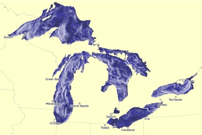
here is an amazing visual representation created by researchers working at the Great Lakes Environmental Research Laboratory (GLERL) that depicts how the currents are moving across the Great Lakes – this is a screenshot from today:
but you should really check out the website, as it is constantly updating, and you can see the ebb and flow and swirling of the currents out on the Great Lakes.
this visualization is made possible with the same computer code that is being used to create the amazing wind map of the United States.

Pretty cool map…I think you sent it once before too!
LikeLike
I think before I posted the wind map! today was the 1st time I saw the water currents map.
LikeLike